Supercell / Tornado Threat Along Retreating Warm Front Southeast SD Through Southern MN
Dr. Reed Timmer, Lead Meteorologist September 21, 2016
A mesoscale convective system (MCS) continues to weaken across northern IL through Lower MI with some regeneration of storms at the southwestern flank near the Davenport area, reenforcing an outflow boundary extending northwest through eastern IA to southwest MN. This OFB intersects with a retreating warm front extending E-W across extreme southern MN to a weak surface low in southeast SD. A slow-moving cold front extends SW from the surface low into central NE. These features will be the focus for severe weather this afternoon and evening especially across southern MN into northeast IA along warm front/outflow boundary, and likely across northeast NE into southeast SD if the cap can be breached this evening along subtle cold front.
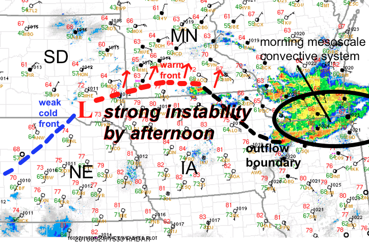
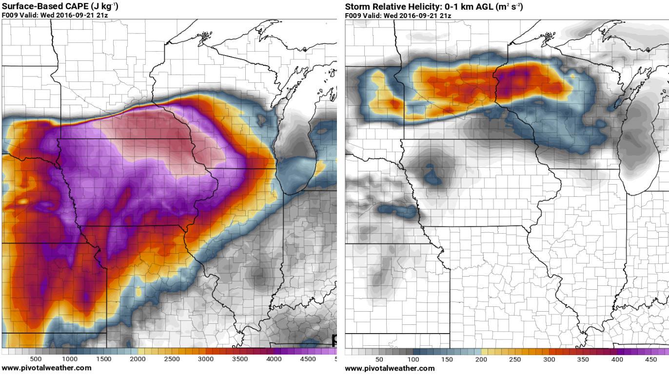
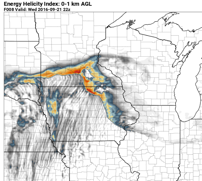
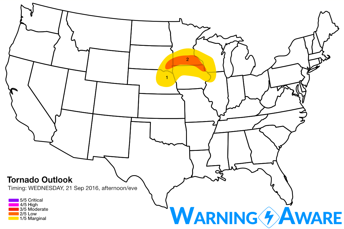
All forecast models show strong instability along and south of the warm front across southeast SD, eastern NE, and southern MN, with dew points in the low 70s and CAPE values in excess of 4000 J/kg by peak heating (see 12z 4 km NAM forecast for 4 pm CDT, below). However, low-level wind shear over most of the warm sector will be very limited south of the warm front and outflow boundary with unidirectional low-level winds/minimal speed shear surface through 700 mb, given the lack of a stronger pressure gradient in the lower atmosphere across the Plains ahead of this subtle shortwave. A stout capping inversion will also limit any convection outside of the above surface features (cold front, warm front, outflow boundary) along the northern periphery of the strong instability. The only areas with a tornado threat (low, 2/5) will be a narrow corridor along and immediately north of the warm front from southeast SD through southern MN where backed surface winds and instability can overlap, and possibly as storms cross the outflow boundary reenforced across northeast IA. Most of the storms will be elevated above the cool, stable air at low levels north of the warm front and OFB, but any surface-based storms that can develop on the unstable side of these boundaries and cross into the enhanced low-level shear near/just N, they likely will produce tornadoes before the individual storms congeal into another mesoscale convective system.
The 4 km NAM and HRRR differ on the evolution of the surface features this afternoon, with the 4 km NAM completely washing out the outflow boundary with the warm front lifting as far northeast as southwest WI, but the morning MCS seems to have been underdone. The HRRR has a better handle on a stronger OFB reenforced by new convection in eastern IA through northwest IL, and shows supercells developing by mid to late afternoon across southeast MN into northeast IA. Both models hint at the potential for supercells also to develop later on with breach of the cap along subtle cold front in northeast NE through southeast SD. Any storms near the southeast SD into southwest MN warm front with this mode could also have isolated tornado potential.
I do think the stable air will remain entrenched across southwest WI as supported by the HRRR and the reenforcement of the OFB across northeast IA, which should keep the tornado threat across extreme southern MN to the south of the Minneapolis - St. Paul area; but the northward progression of the warm front should be monitored through this evening. Given uncertainties expected with storm coverage and the sustenance of surface-based storms along and just north of the warm front/OFB before formation of an MCS, have included the narrow corridor of instability/low-level shear overlap across southeast SD, southern MN into extreme northeast IA in a low, 2/5 tornado threat for afternoon/evening. However, depending on how much instability develops just north of the warm front, these numbers could be justifiably increased.
WarningAware provides a highly customizable service to monitor weather and emergency alerts for businesses and organizations.
Our service can monitor your locations for alerts and send intelligent notifications to both internal and external contacts.
Learn More