Tornado and Hail Threat Return to the Southern High Plains!
Dr. Reed Timmer, Lead Meteorologist May 15, 2016
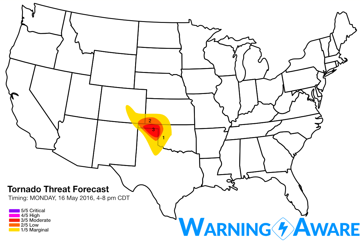
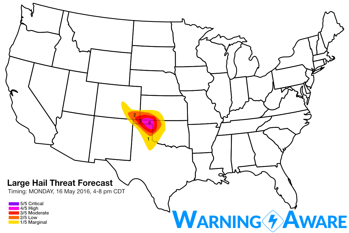
Forecast models have come into agreement on the likelihood for significant severe weather across the northern TX/OK Panhandle region on Monday afternoon/evening, possibly into extreme southwestern KS depending on the northward push of the warm front. A compact but potent jet streak will pass over the TX/OK Panhandles right at peak heating, with supercells quickly initiating first over southeast CO by early afternoon, and then east of the surface low along dry line/warm front intersection near Guymon, OK into the northern TX Panhandle by 3-4 pm! Very large hail and tornadoes will be likely with the dominant supercells in this region tomorrow between 4-8 pm. Based on the magnitude of instability and wind shear expected in the warm sector, we've deployed a moderate (3/5) threat for tornadoes, high (4/5) for large hail centered over the northeast TX Panhandle, eastern half of the OK Panhandle, and extreme southwest KS.
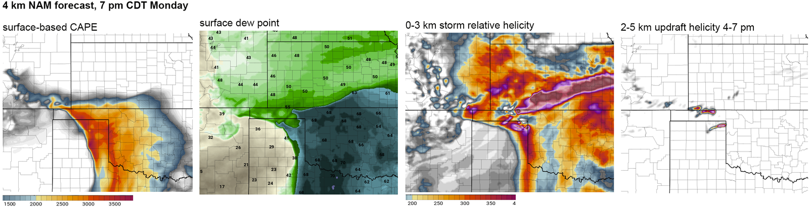
Analysis of the latest 4 km NAM output shows best the surface features and parameters of interest, including a tongue of 60F and greater dew points surface north and northwest to the central OK Panhandle/extreme southwest KS by 3-4 pm, which is more than sufficient for low, tornado-conducive cloud bases this far west. With cold air aloft associated with the upper-level trough to the west and a stout elevated mixed layer expected to clear out skies allowing for plenty of surface heating, CAPE values will surge about 2500 J/kg for eastern half of OK Panhandle south through the eastern TX Panhandle by late afternoon/evening. The greatest tornado threat will be the 2-3 supercells from the central OK Panhandle down through the Canadian, TX area, especially after 5-6 pm when the low-level jet ramps up. The supercells ingesting the enhanced streamwise vorticity with ESE surface winds near the warm front/just E of surface low in this same area will have a strong tornado threat by late afternoon/evening.
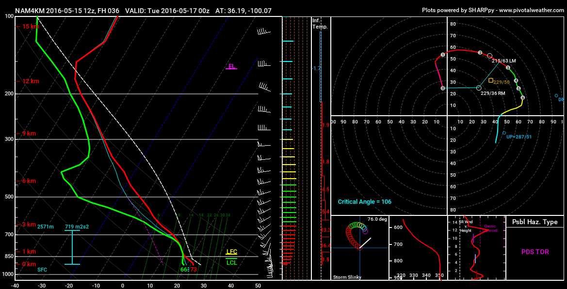
Forecast soundings from the northeast TX Panhandle at 7 pm tell the story, with thermodynamic and kinematic profiles TEXTBOOK for strong tornadoes, with strong wind magnitudes and changing of wind direction with height contributing for very large hodographs. Storm motions also support strong tornadoes with the near 90 degree angle between the low-level shear and storm motion vectors.
Stay safe and severe weather aware in this region tomorrow afternoon/evening! I'll be targeting Guymon, OK to Canadian, TX by 3 pm.
WarningAware provides a highly customizable service to monitor weather and emergency alerts for businesses and organizations.
Our service can monitor your locations for alerts and send intelligent notifications to both internal and external contacts.
Learn More