Significant Severe Weather, Tornadoes Possible Today from Dixie Alley to the Lower Great Lakes
Dr. Reed Timmer, Lead Meteorologist March 31, 2016
Potentially significant and geographically expansive severe weather, tornado threat this afternoon/evening from the Lower Mississippi River Valley to as far north as the southern Great Lakes Region…
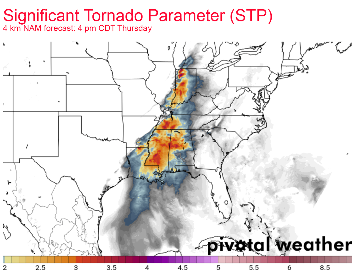
Since I have to hit the road ASAP here in eastern Arkansas for my target area of northern Mississippi for this afternoon, I’ll have to make this severe weather discussion a bit less detailed. The latest NAM forecast significant tornado parameter or STP below for 4 pm CDT tells the story of a widespread tornado threat from Louisiana and Mississippi north through eastern Illinois and Indiana. It looks like there could be multiple modes of severe weather with today’s outbreak, starting with the northern mode along the cold front surging through Illinois by early afternoon. Here, multiple supercells will contribute to a very large hail threat including the risk for isolated tornadoes starting by 1-2 pm. A southern mode will also materialize across the Lower Mississippi River Valley by mid-afternoon with a greater threat for strong, long-track tornadoes across extreme eastern AR, central/northern MS, western TN, possibly northern AL later on. Supercells should develop rapidly along the cold front in eastern AR and along residual outflow boundaries by 2-3 pm and move rapidly ENE. Cities like Memphis, TN, Huntsville, AL and Nashville, TN could be impacted by these supercells.
 Model imagery by: pivotalweather.com
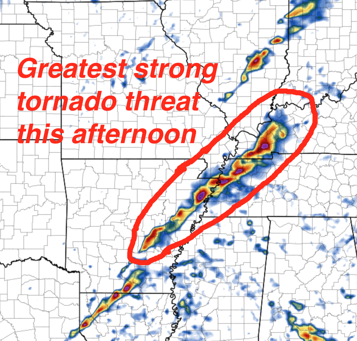
The hodographs look most favorable for tornadoes, including strong tornadoes, across northern MS, western/central TN, through northern AL especially when a locally backed surface wind near residual outflow boundary is assumed. Wind shear throughout the warm sector overall is much stronger and expansive than yesterday, with only a pair of tornadic supercells moving through northeast OK including the North Tulsa area, with a tornado narrowly missing the Tulsa Airport. There were other tornadic supercells yesterday near the warm front in extreme northeast Texas southwest of Texarkana, but overall the tornado threat was limited especially east of the dry line yesterday. Today, if there is a surface-based supercell in our target area it likely will have a tornado on the ground or in the process of doing so. I’ve outlined the greatest threat for strong tornadoes below.
 Model imagery by: pivotalweather.com
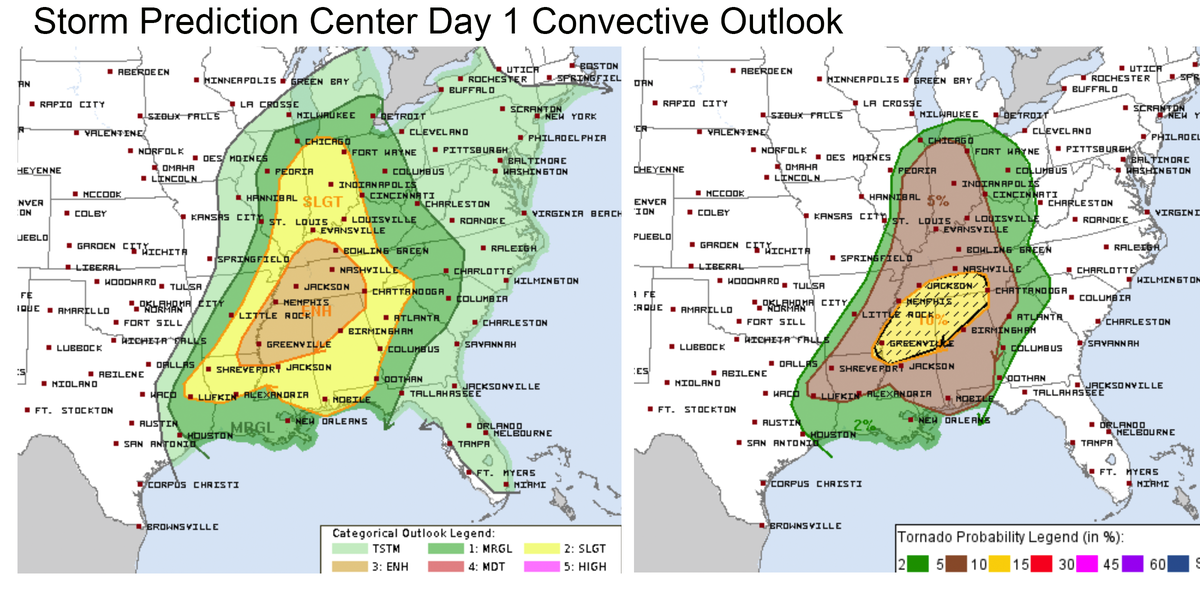
Here is the latest day 1 convective outlook from the Storm Prediction Center this morning, with an enhanced risk for severe weather including hatched area for strong tornadoes across northern MS, northern AL, into western/central TN. Stay safe out there!
WarningAware provides a highly customizable service to monitor weather and emergency alerts for businesses and organizations.
Our service can monitor your locations for alerts and send intelligent notifications to both internal and external contacts.
Learn More