Potentially Significant Severe Weather Event Wednesday
Dr. Reed Timmer, Lead Meteorologist March 28, 2016
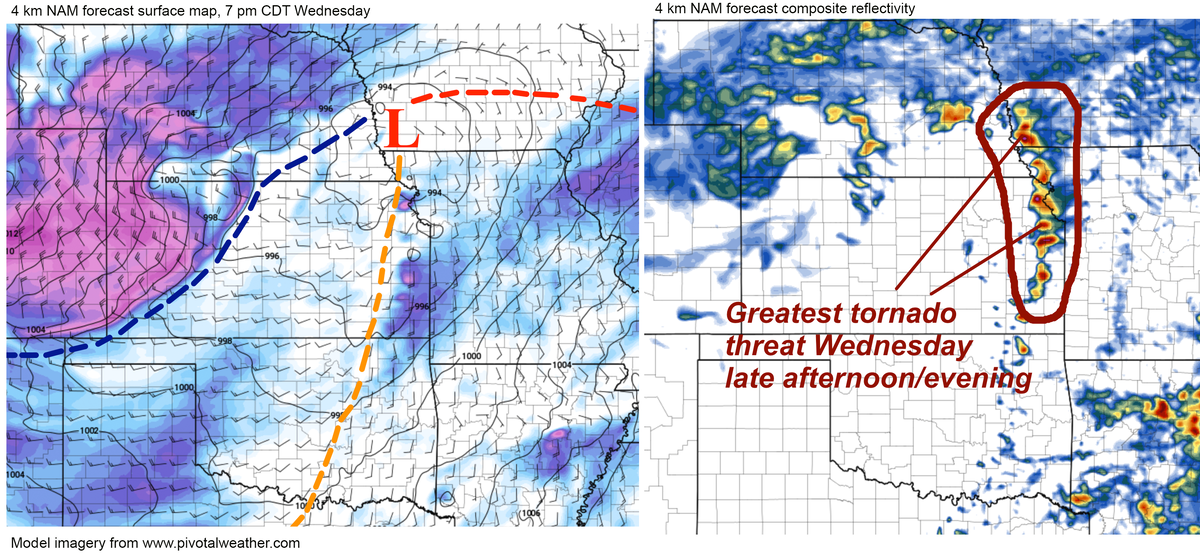
Forecast confidence is increasing for a potentially widespread severe weather event this Wednesday afternoon/overnight across parts of the southern Great Plains, including tornado potential. A massive trough will amplify over the western U.S. through Wednesday, with rapid northward moisture transport from the Gulf of Mexico expected to commence tomorrow. By Wednesday afternoon, a sharp dry line will be in place across Northwest Texas, central Oklahoma through eastern Kansas to a surface low in eastern Nebraska, with dew points surging into the 60s in the warm sector. The greatest instability will likely reside from southwest Kansas into North Texas, but the wind shear most conducive for tornadoes will likely be with the northern mode closer to the surface low (eastern KS, northwest MO, southern IA). I’ve included 4 km NAM forecast maps of surface dewpoint and CAPE at 7 pm Wednesday below. Keep in mind this forecast is subject to change.
 Model imagery by: pivotalweather.com
Typically the greatest supercell/tornado threat with storm systems like this exists near and just north of any dry line bulge, or where the boundary is oriented more N-S closer to the surface low. Here, storm motions are more perpendicular to the dry line and more readily move off the boundary into the stronger wind shear and deeper moisture just to the east, and remain discrete. Typically the wind shear/hodographs are more conducive for tornadoes with the stronger kinematics (wind fields) and directional shear closer to the surface low/upper-level jet stream exit region, and at least with these model forecasts, that location looks to be in eastern KS/northwest MO/southern IA. I’ve delineated the important surface features/boundaries along with forecast composite reflectivity for Wednesday evening below.
Model imagery by: pivotalweather.com
In my blog post tomorrow, I’ll explain the fundamentals of using hodographs in forecasting to assess how favorable is the wind shear for tornadoes, and what we look for to determine strong tornado potential. Based on my initial analysis of the shear profiles throughout the warm sector on Wednesday late afternoon/evening, I certainly would not rule out the potential for strong tornadoes if these current models are accurate across eastern KS/northwest MO/even southern IA. There could also be a secondary area of enhanced severe weather to the south in northeast TX/eastern OK Wednesday night, with the severe threat focused across Dixie Alley on Thursday as the trough begins to eject to the northeast. More flooding will be possible across the south-central U.S. by Thursday.
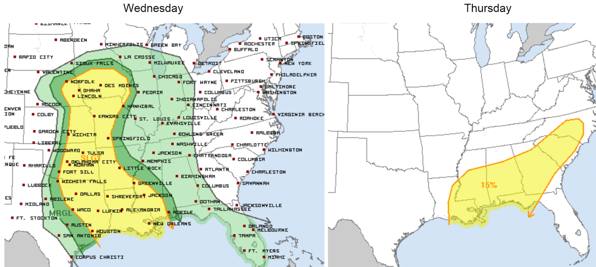
I’ve included the Storm Prediction Center day 3 and 4 convective outlooks below for Wednesday and Thursday, respectively. If you live in these areas be sure to have your NOAA weather radios charged up and practice your family severe weather safety plans! I’ll continue to update you on the forecast. In the long-range, it looks like a seasonably cold, Arctic air mass could take over the northeast U.S. for the first week of April behind this system, then more severe weather in the Plains behind that regime.
WarningAware provides a highly customizable service to monitor weather and emergency alerts for businesses and organizations.
Our service can monitor your locations for alerts and send intelligent notifications to both internal and external contacts.
Learn More