Blizzard Warning Issued for Denver Metro Area!
Dr. Reed Timmer, Lead Meteorologist March 22, 2016
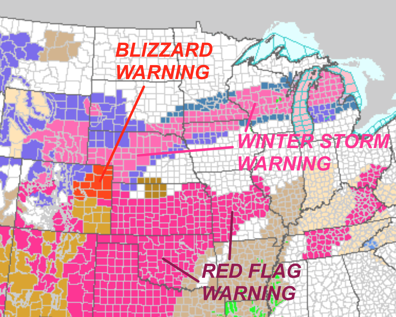
A BLIZZARD WARNING has been issued for northeastern Colorado including the Denver Metropolitan area, for 6-12” of snow with winds gusting over 50 mph between 4 am and 6 pm on Wednesday. Denver International Airport and other locations just east of Downtown Denver will likely the strongest winds and most persistent whiteout conditions, which will inevitably shut down flights into DIA for most of the day.
Winter storm warnings have been issued for western/northern NE, southeast SD, southern MN, northern IA, through central WI and northern Lower MI. A majority of forecast models show the heaviest snowfall totals from this system across southeast MN and central WI, with over a foot possible by Thursday morning.
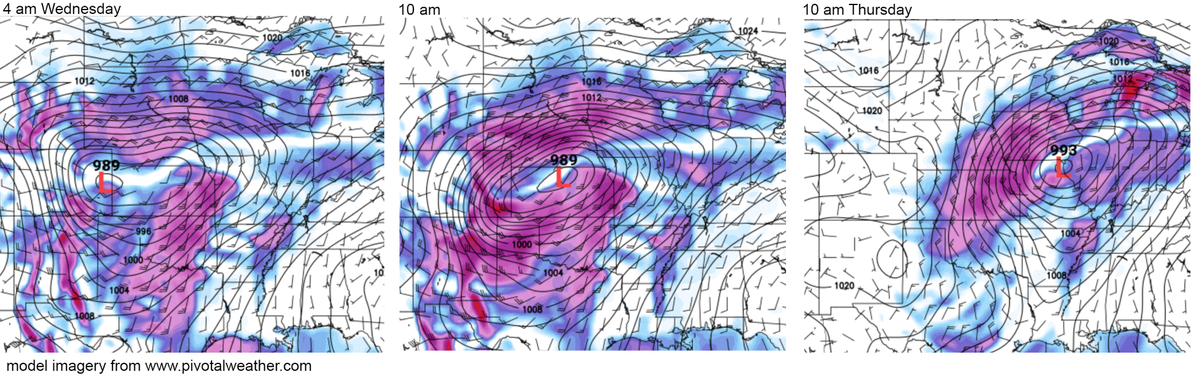
The latest GFS model images below for surface pressure and wind show the evolution of the potent surface low after developing/intensifying rapidly tonight in eastern Colorado, reaching a minimum below 990 mb by Wednesday morning. The strongest winds over northeast Colorado will arrive by mid/late morning tomorrow with the backside of the intensifying surface low, which will move quickly across northern KS during the day Wednesday with a monster clear slot shutting down snowfall rates in central/southern NE. Snow will already have begun across the entire winter storm warning area by Wednesday evening as the surface low maintains or slightly weakens toward the Great Lakes Region.
The NAM model has consistently shown the greatest snowfall totals across the southeast MN through central WI target area, with very heavy snowfall rates Wednesday night through Thursday morning after the wintry mix changes over to all snow. The GFS also shows nearly a foot and a half of snow from Rochester, MN/LaCrosse, WI areas with a maximum in central WI. The heavy snow will have the longest duration in this region for the entire storm system, continuing through Thursday morning.
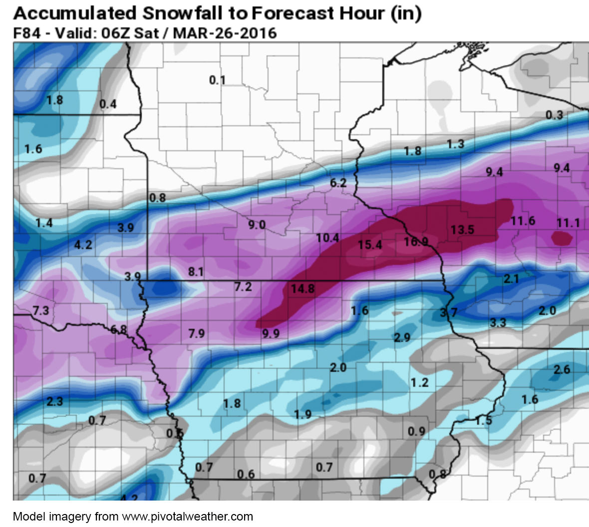
Right now, the Minneapolis – St Paul, MN area is still under a winter storm watch, because any shift to the north of the surface low track would bring the narrow band of heavy snow into MSP. Any location within this band of snow will have major problems and very dangerous travel conditions for the Thursday morning commute.
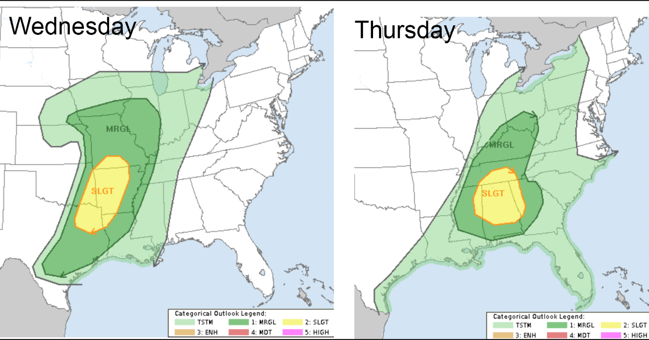
There will also be a severe weather threat in the warm sector of this storm system on Wednesday (extreme eastern OK, western AR, northeast TX, southern MO) and on Thursday in central Dixie Alley (central/northern AL, southern TN), with damaging straight-line winds and hail the main threats. Different from previous systems this late winter/spring, the tornado threat will be relatively minimal due to low-level moisture limitations and marginal wind shear profiles, so I’ll be covering the cold side of this system in the Rochester/LaCrosse areas. Still though, stay tuned to local media and charge up your weather radios in the slight risk areas from the Storm Prediction Center below.
The next storm system to impact the U.S. will be on Saturday/Sunday, with a severe weather threat possible for the southern Great Plains initially, possibly extending into Dixie Alley by the end of the weekend.
WarningAware provides a highly customizable service to monitor weather and emergency alerts for businesses and organizations.
Our service can monitor your locations for alerts and send intelligent notifications to both internal and external contacts.
Learn More