Large Hail Possible in Central/Southern Texas and Louisiana
Dr. Reed Timmer, Lead Meteorologist March 18, 2016
A very large slight risk area for severe weather has been issued by the Storm Prediction Center for today, covering much of central/southern TX, LA, central/southern MS, and even extreme southern AR. Different than previous setups in this region so far this spring, however, the tornado threat should be very minimal. Large, damaging hail will be the main threat with very cold air aloft and decent instability, especially across parts of central/southern TX.
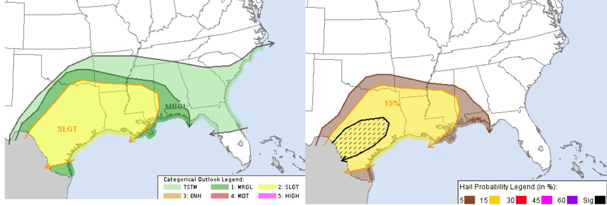
With -15C temperatures at 500 mb across the entire southern Plains through Lower MS River Valley and a warm, moist environment ahead of the cold front, severe hail will be possible this afternoon/evening across the entire slight risk area. Short-range model (RAP) forecast of 0-3 km energy helicity index shows best the greatest risk areas for large hail this afternoon/evening, which is a composite index of instability and wind shear in the lowest 3 km of the atmosphere. The maximum EHI values ahead of the surging cold front are forecast to be over the southern Hill Country of Texas extending east to maybe the I-35 corridor between DFW and Austin. This is the region where deep-layer shear, instability, and the likelihood of storms overlay the strongest, with another area of relatively greater hail potential in the central Gulf Coast from Lake Charles through the New Orleans area. This pattern has been a roofing construction workers dream come true for early spring in TX, but usually is associated with dangerous severe weather as well. Thankfully at least the tornado threat is not a major concern for this system.
The lack of wind shear in the lowest 1 km of the atmosphere in the warm sector is the main reason any storms this afternoon/evening will likely not produce tornadoes (see 0-1 km storm relative helicity forecast panel for 5 pm CDT, below, right), but deep layer shear is still sufficient for any isolated storms to organize into supercells. The surface-based and elevated supercell storms that become dominant in the above hail regions will drop the most damaging hail to over golf ball size, especially from north of Del Rio through the Ozona / San Angelo, TX areas east to I-35 by late afternoon/evening.
WarningAware provides a highly customizable service to monitor weather and emergency alerts for businesses and organizations.
Our service can monitor your locations for alerts and send intelligent notifications to both internal and external contacts.
Learn More