Severe Weather Recap
Dr. Reed Timmer, Lead Meteorologist March 14, 2016
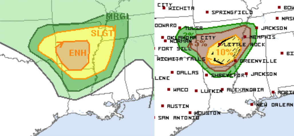
Storm season has started with a BANG across parts of the southeastern Great Plains through the Lower Mississippi River Valley, with another 4-5 tornadoes and over 40 severe hail/wind preliminary reports yesterday across eastern Oklahoma, Arkansas and northwestern Mississippi. While the metro areas of Little Rock and even Memphis were threatened by tornadic supercells and tornado warnings through evening, thankfully, there were no reports of injuries or loss of life from these storms. The Storm Prediction Center had an enhanced risk for much of central/southern AR well in advance of yesterday’s event, including the addition of a strong tornado threat.
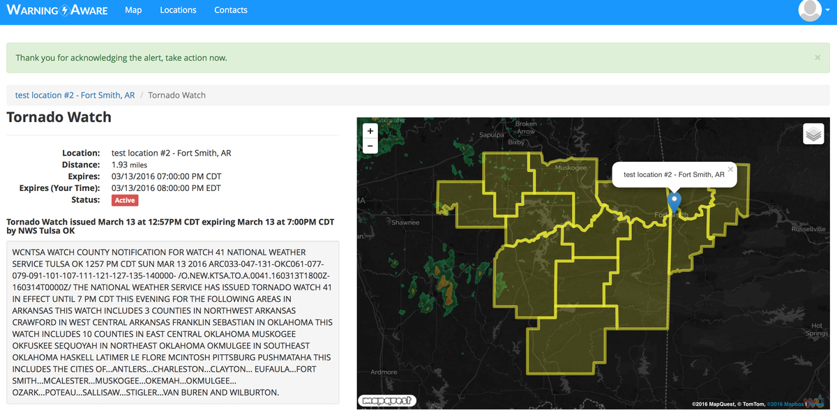
The first tornado watch of the day was issued just before 1 pm CDT yesterday for much of eastern Oklahoma into extreme western Arkansas, including just east of the OKC Metro and Fort Smith, AR. Storms developed first in eastern Oklahoma with the heating of the day in an arc just ahead of the compact, cold upper-level low that would quickly swing east across Arkansas later on.
The Warning Aware team began receiving alerts for this first Tornado Watch at one of our test locations for the day in Fort Smith, AR, with more successful test alerts for for severe weather warnings at locations downstream in Arkansas.
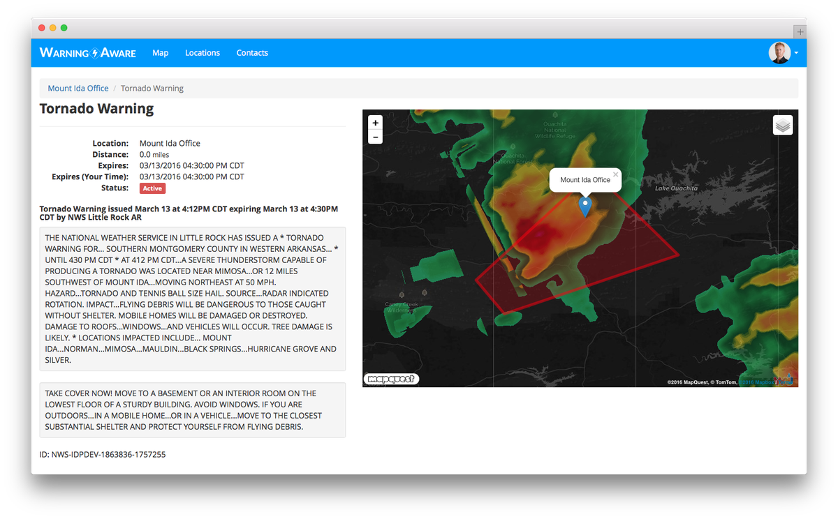
Even though the first storms in eastern Oklahoma were rotating immediately after initiation, the main tornado threat did not emerge until supercells moved into or developed in the strongly sheared environment to the east over Arkansas. As this compact upper-level trough ejected east, the first tornado warned storm developed in southwest Arkansas and moved toward the Mount Ida area. While no storm chasers were on this initial supercell to my knowledge, it did look like it may have produced a few brief tornadoes in the rural, forested terrain there based on radar.
As this tornadic supercell was approaching the Mount Ida, AR area, another storm was gaining strength off to the east over Interstate 30 to the southwest of Little Rock. This new storm quickly became supercellular with multiple storm chasers streaming live as it made a bee-line toward Little Rock. Thankfully, this storm turned right just south of Downtown Little Rock, but still closed within the outer threshold I set for my test location there and was receiving real-time alerts through text and email throughout. There were reports of tornadoes with this supercell from just south of I-40 southeast of Little Rock, but I have not yet seen any confirmation photos.
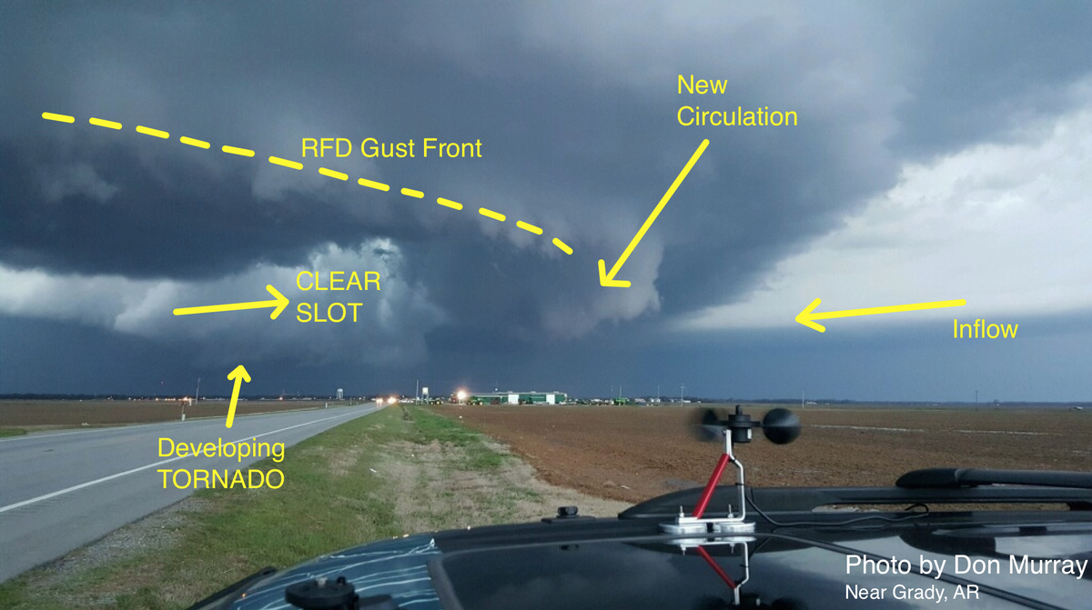
Several more supercells would develop in southeast Arkansas during the late afternoon/evening in an even more strongly sheared environment, including this storm with TEXTBOOK structure near Grady, AR that would go on to produce a cone tornado. Beautiful LP/classic structure like this is more common than you would think during the early spring, even in the Lower MS River Valley, especially with more limited low-level moisture quality. I’ve delineated a few main features of basic tornadic supercell structure in the photo of the Grady, AR supercell below, used with permission from storm chaser Don Murray. Here is a video of the Grady, AR tornado from Scott Peak of the Basehunters Storm Chasing Team.
A cone tornado with power flashes was also reported after sunset with this same eastern cluster of supercells crossing Highway 1 just north of Lexa, AR. This supercell would eventually trigger a tornado warning for Downtown Memphis, but thankfully the circulation passed just to the south and with no confirmed reports at this time. Nevertheless, it was a scary situation last night in the Memphis area with residents there all-too-familiar with damaging tornadoes at night.
More severe weather is likely across parts of the Upper Midwest tomorrow. I’ll post more forecast updates as the target area becomes more clear.
Dominate the storm,
Reed
WarningAware provides a highly customizable service to monitor weather and emergency alerts for businesses and organizations.
Our service can monitor your locations for alerts and send intelligent notifications to both internal and external contacts.
Learn More