Severe Weather Returns to the Plains This Weekend, Including Threat for Hail and Tornadoes
Dr. Reed Timmer, Lead Meteorologist May 06, 2016
An elongated, SW-to-NE oriented cut-off low will move slowly across the southern Rocky Mountain Region through the weekend, with rapid northward moisture transport across the Great Plains ahead of this storm system. A vast majority of the strongest upper-level winds (> 100 kts at 300 mb) are confined to the southern side of this cut-off low, with a potent jet streak/associated jet exit region forecast to impinge on the High Plains tomorrow. In response, a strong surface low will develop over northeast Colorado tomorrow morning, with upper 40s/lower 50s dew points advecting westward across the High Plains by afternoon via strong low-level easterlies mainly north of I-70 in CO.
The image below shows latest 4 km NAM forecast surface dew point (left) and 0-3 km storm relative helicity at 3 pm MDT, clearly indicative of an environment supportive of supercells and isolated tornadoes at this elevation in northeast CO.
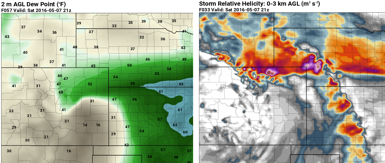
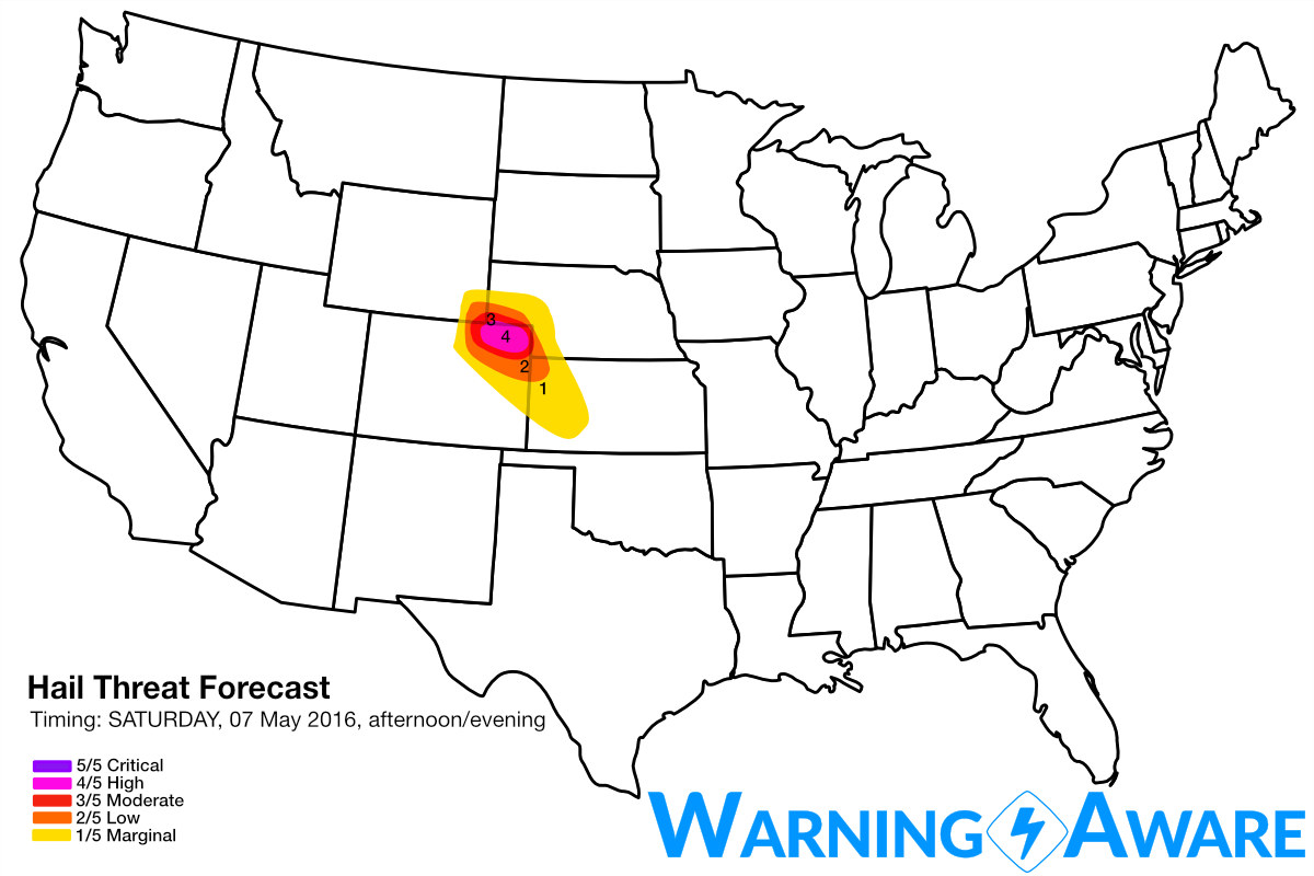
Instability will build with the heating of the day across northeast CO along/north of I-70, with an arc of supercells producing large hail and isolated tornadoes likely impacting parts of northeast Colorado by tomorrow (Saturday) afternoon/evening. Storms will initiate off the Mountains near or north of Denver as early as 1-2 pm and quickly go supercellular over the adjacent high plains, and then move north and east toward the southeast WY/NE Panhandle border by evening. With very cold temperatures just above the ground over northeast CO (< -19C at 500 mb) overtop warm, moist low levels tomorrow afternoon, the stage will be set for large hail with any dominant supercell storms in this region. Given the anticipated high number of storms expected across northeast CO, many of which will likely will be rotating, we've decided to add a "high" (4/5) severe hail threat here including Fort Morgan to Sterling, CO and surrounding areas. The greatest threat for severe hail will be north of I-70.
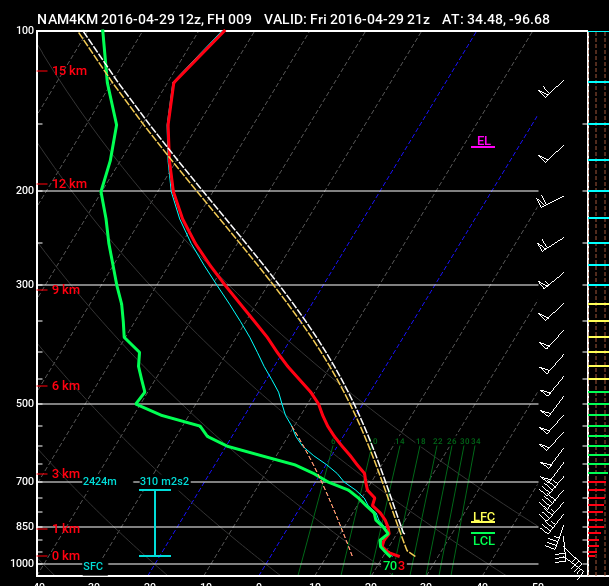
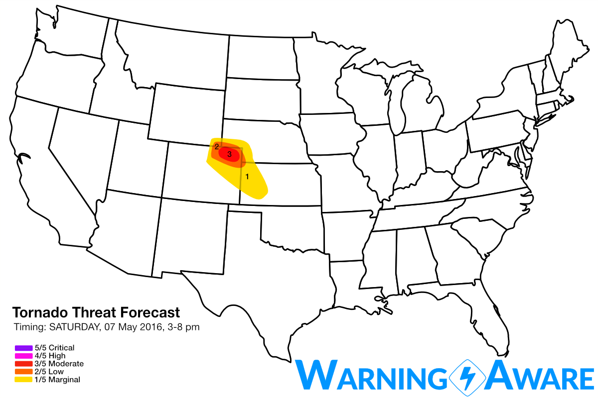
The only potential limiting factor for a more substantial tornado event tomorrow afternoon in northeast Colorado is if the moisture return is not as robust across the high plains yet by Saturday, but it doesn't take much more than dew points in the mid to upper 40s to have tornadoes especially closer to the mountains in CO. Forecast soundings between Greeley and Sterling, CO, even from east of Cheyenne, WY into the southern NE Panhandle are very supportive of tornadic supercells tomorrow afternoon between 21 and 00z (3 and 6 pm MDT), so have issued a small moderate (3/5) tornado threat area. The forecast sounding from the 4 km NAM west of Sterling at 3 pm tomorrow afternoon shows the strong easterly low level flow shifting to SSW at upper-levels, with strong instability and surface-based CAPE values well in excess of 1000 J/kg.
The severe weather threat then shifts to the eastern TX Panhandle into western Oklahoma for Sunday, including large hail and isolated tornadoes, shifting to the east by Monday. I'll post new severe weather discussions for Sunday and Monday once we get through tomorrow's forecast. Stay safe out there.
WarningAware provides a highly customizable service to monitor weather and emergency alerts for businesses and organizations.
Our service can monitor your locations for alerts and send intelligent notifications to both internal and external contacts.
Learn More